Claim Drops at Uranium Juniors: What Strategic Focus Signals
September 5, 2026
Copper Price at Record High: What It Means for Investors
September 7, 2026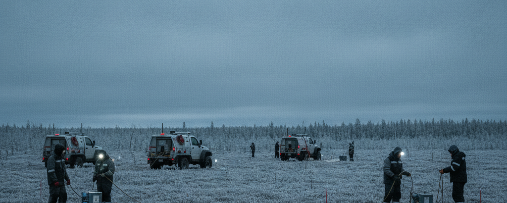
Before the first meter is drilled: the quiet groundwork of geophysics
In uranium exploration, one straightforward truth holds: drilling is expensive, geophysics is comparatively cheap. A single drill meter in the deep, water-bearing rock formations of the Athabasca Basin in Saskatchewan can cost several hundred dollars; a complete borehole can quickly run into the hundreds of thousands. Junior companies operating with limited capital cannot afford to drill blind. That is precisely where modern exploration geophysics comes in. It does not deliver deposits, but it sharpens the picture enough to direct capital toward locations where the probability of a discovery is highest.
Two methods have seen growing use among uranium juniors in Saskatchewan: mobile magnetotellurics (MT) and ground-based gravity surveys. An exploration program that evaluates this kind of geophysical data before the drilling phase begins makes better-informed decisions than one that moves directly from an airborne survey to the drill. For investors, that difference matters.
The Athabasca Basin as a case study in modern exploration methods
The Athabasca Basin in Saskatchewan ranks among the most uranium-rich regions in the world. The unconformity-type deposits found there sit at the boundary between ancient basement rock and younger sandstone, often at depths between 300 and more than 600 meters. This creates a real methodological problem: the deposits are geologically precise in their positioning, yet invisible from the surface.
Conventional magnetics or airborne electromagnetic surveys (TDEM/VTEM) are a useful first step, but they reach their limits at greater depths and beneath conductive cover sequences. Mobile MT and ground gravity address this — not as universal solutions, but as techniques that measure different physical properties of the subsurface and together produce a more detailed picture of a potential target zone than any single airborne survey can.

What MT and gravity actually measure
Mobile magnetotellurics (MT) is a passive electromagnetic technique that uses naturally occurring electromagnetic fields — generated by thunderstorms and fluctuations in the Earth’s magnetic field — to measure the electrical resistivity of the subsurface at various depths. Fault zones, altered rocks, and water-bearing layers all modify this resistivity in characteristic ways. In uranium exploration, graphite zones and altered shear zones are particularly relevant, as they frequently occur near unconformity-type deposits and show low electrical resistivity.
The key advantage of mobile MT is depth penetration. While many electromagnetic methods lose resolution at depth, MT can return usable signals from several hundred to more than a thousand meters below surface — which matters in the Athabasca Basin, where the economically significant unconformity lies well below the reach of most airborne tools.
Ground gravity surveys measure local variations in the Earth’s gravitational field. The geological logic is concrete: different rock types have different densities. Granitic basement rocks are denser than the overlying sandstone; fault zones with altered mineral assemblages produce different gravity signatures. In uranium exploration, a gravity survey can map depressions in the basement — paleochannels or structural lows — where uranium-bearing fluids may have concentrated over geological time.
| Method | Property Measured | Typical Depth Range | Uranium Exploration Advantage |
|---|---|---|---|
| Mobile Magnetotellurics (MT) | Electrical resistivity | 300–1,000+ meters | Mapping shear zones and graphite at great depth |
| Ground Gravity | Local gravity variation | Surface to several hundred meters | Identifying basement structures and paleochannels |
| VTEM (airborne) | Electromagnetics | Up to ~300 meters | Large-scale initial detection of conductive layers |
What a well-structured exploration program means for investors
For newcomers to the small-cap world, distinguishing between exploration phases is often difficult. A rough guide: the more geophysical pre-work a company completes before drilling, the higher the general probability that a borehole will encounter something geologically worth examining — even if it does not confirm mineralization.
When a junior explorer says that an MT survey filtered three or four drill targets from an original ten anomalies, that is a different statement than if the same company moved straight to drilling after an initial airborne survey. More data before the drill goes in means better-informed decisions.
Geophysical surveys do not replace the drill core. They generate hypotheses. An investor who understands this hierarchy — anomaly, then priority target, then drill intercept — can read junior company press releases with more clarity. “Three new priority target areas identified” is methodological progress, not a resource confirmation.
Target definition: an evaluation criterion many investors overlook
In a market where uranium juniors are often assessed on the same surface-level criteria — land package size, proximity to known deposits, management track record — the quality of the geophysical program rarely gets attention. It should. A program that moves from airborne surveys to ground-based geophysics before committing to drill targets shows that the company is spending its money with some discipline.
The value of an exploration project cannot be read from the size of the concession area or the number of planned drill holes alone. Which methods are used, and in what sequence, says more about the scientific approach than any headline figure in a press release.
Key terms explained
- Magnetotellurics (MT)
- A passive geophysical technique that uses naturally occurring electromagnetic fields to measure the electrical resistivity of the subsurface at various depths. Particularly effective at great depths where other electromagnetic methods fail.
- Ground gravity survey
- A ground-based measurement of local variations in the Earth’s gravitational field. Density differences between rock types produce measurable anomalies that can indicate structural features such as paleochannels or fault zones.
- Unconformity-type deposit
- A deposit type that forms at the interface between ancient basement rock and younger cover rock. Characteristic of the Athabasca Basin in Saskatchewan; often very high-grade but located at considerable depth.
- Anomaly (geophysical)
- An area where a measured physical parameter — such as resistivity, gravity, or magnetics — deviates statistically from the background value. An anomaly is an indication, not proof, of a mineral deposit.
- Priority target
- An anomaly or combination of anomalies that, after evaluation of multiple datasets, is ranked as particularly drill-ready. This classification is an internal ranking and does not substitute for independent technical review.
- NI 43-101
- A Canadian regulatory standard (National Instrument 43-101) that sets requirements for public disclosure of mineral resources and reserves. It strictly distinguishes between Resources (Inferred / Indicated / Measured) and Reserves (Probable / Proven).
- Exploration capital efficiency
- The ratio between exploration capital deployed and the quality of geological information generated. A program with high capital efficiency produces more geologically usable data per dollar spent.
⚠️ Important notice: This article is for informational and educational purposes only. It does not constitute investment advice, a recommendation, or a solicitation to buy or sell any security. Investments in small-cap exploration and mining companies carry a high risk, including the potential total loss of capital. Before making any investment decision, consult a registered financial advisor and conduct your own analysis. Boersen Post Team is not responsible for decisions taken based on the content published here.